Sediment Mapping
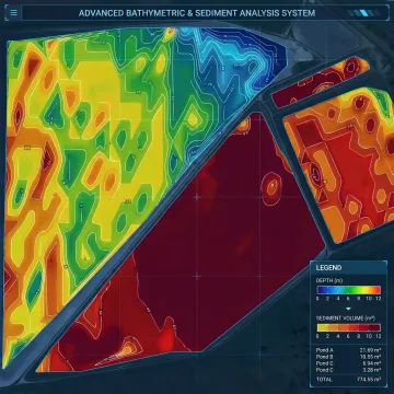
Map sludge accumulation across noncovered ponds and lagoons using advanced sonar and GPS data. This service identifies sediment thickness, volume, and infill patterns to support maintenance planning and dredging decisions.

Get precise pond mapping services that turn sonar and GPS data into clear, actionable bathymetry and surface survey insights. Bristola helps operators understand depth changes, sediment buildup, and pond conditions so they can plan maintenance, improve water quality, and budget dredging with greater confidence and less guesswork.
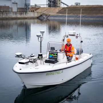
Targeted pond and lagoon survey solutions that deliver depth, sediment, and condition data for smarter maintenance planning.
Map sludge accumulation across noncovered ponds and lagoons using advanced sonar and GPS data. This service identifies sediment thickness, volume, and infill patterns to support maintenance planning and dredging decisions.
Capture accurate depth data across the full pond footprint to produce detailed bathymetric models. GPS-referenced surveying helps operators understand contours, average depths, and maximum depths with confidence.
Survey pond boundaries and surrounding surface conditions to support a more complete site picture. Surface data complements underwater mapping for reporting, planning, and long-term asset management.
Bristola delivers pond mapping services that help operators see below the surface and plan with confidence. Using advanced sonar, GPS technology, and detailed reporting, we provide accurate bathymetry, sediment measurements, and surrounding surface data for noncovered ponds and lagoons. The result is a clearer understanding of current conditions, better dredging forecasts, and more informed maintenance budgeting.
See how operators use our mapping data to plan maintenance and improve pond performance.
We combine safety-first innovation with practical survey data operators can use.
Focused experience with ponds, lagoons, and liquid storage systems across demanding industrial environments.
We turn sonar and GPS findings into usable visuals for dredging, budgeting, and maintenance planning.
Built by a company known for reducing confined-space risk and improving field safety standards.
Our technology-first mindset helps clients make faster, better-informed operational decisions with reliable field data.
Experienced leaders driving safer, smarter field solutions.

Founder
Jared Burma is the Founder of Bristola, a pioneering clean technology company he established in 2019 following a near-death experience inside a storage tank that forever changed his perspective on industrial safety. That life-altering moment ignited a passion to create a safer, more efficient alternative to traditional tank cleaning methods. Driven by a deep belief in the future of renewable clean energy, Jared transformed a bold Midwest idea into a global operation serving clients across the United States, Canada, Europe, the Middle East, Australia, and India. His vision led to the development of a patented, zero-human-entry robotic cleaning system that eliminates operational downtime and protects worker lives. Jared continues to lead Bristola with unwavering commitment to innovation, safety, and a cleaner future for industries worldwide.
Pond mapping is the process of measuring underwater depths, bottom contours, and sediment accumulation to create a detailed picture of pond conditions. It is important because it helps operators identify capacity loss, uneven settlement, and sludge buildup before those issues affect performance. Accurate mapping supports maintenance planning, dredging budgets, water quality improvements, and better long-term asset management.
Talk with our team about survey scope and reporting.
Bristola supports pond and lagoon survey needs across broad service regions for industrial and commercial operators.
U.S. & International
Service Reach
Des Moines, IA
Headquarters
Multi-Sector Support
Industries Served
Ask our team about survey availability for your site.

Proprietary technology supporting safer access methods.
Six years of focused industry innovation.

Serving clients across multiple continents.
Tell us about your pond or lagoon, current conditions, and survey goals. Our team will review your needs and help outline the right mapping approach.
To help us assist you faster, please include the reason for your message so the relevant team can reach out as soon as possible.
To help us assist you faster, please include the reason for your message so the relevant team can reach out as soon as possible.